
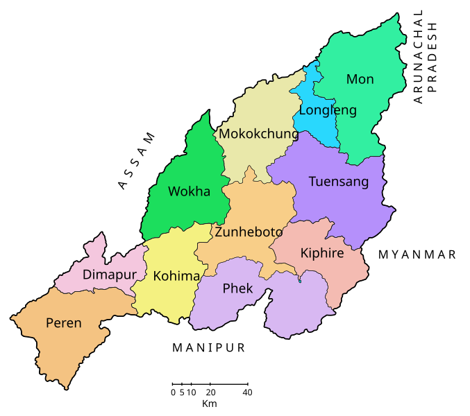
Nagaland
‘Land of the Nagas’

NEXT STOP: NAGALAND
Please alight for:
• India’s hottest chilli
• The falcon capital of the world
• The Hornbill Festival
Car 2 is reserved for Amur falcons — please keep snacks hidden.
Car 3 is a mithun breeding farm — mind the horns (and the hooves).
Car 6 has been converted into a rhododendron nursery — do not water
The buffet car is now serving dried Axone pork and Zutho rice brew.
Welcome to Nagaland

NAGALAND
‘Land of the Nagas’
Nagaland has sixteen major tribes, each with its own language, clan structure, ceremonial calendar and oral tradition. The term Naga itself is a loose colonial umbrella, its etymology disputed — Bur/Kachin: no-ka (‘pierced ears’) is often cited, but Sanskrit: nāga (‘serpent’), naga (‘mountain’) and nagna (‘naked’) are also proposed. None command consensus.
Much of the region remained unmapped and autonomous until the late 19th century. Administrators, missionaries and anthropologists arrived slowly: J. H. Hutton and J. P. Mills pioneered early administrative ethnography, but it was Christoph von Fürer-Haimendorf who left the most vivid record of Naga life. Working in the 1930s and 40s, he photographed, filmed and sketched Angami, Konyak and Zeme communities. His images of morungs, shawls, festivals, architecture and everyday labour form an irreplaceable visual archive of pre-missionary Nagaland.
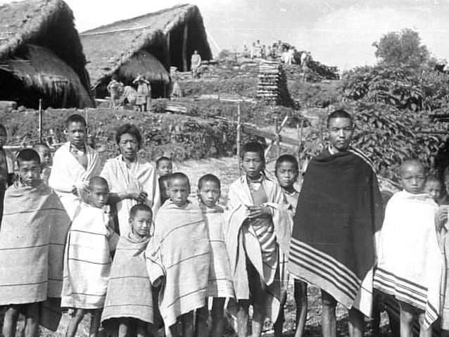
Verrier Elwin, though better known for his work in Central India, played an important role in the Naga Hills during the 1940s. He urged the Indian government to recognise the distinctiveness of village republics, customary law and clan authority, arguing that rapid assimilation would destroy these ancient hill societies. His advocacy helped shape discussions that ultimately fed into the Sixth Schedule and India’s wider thinking about tribal autonomy.
Together, Elwin and Haimendorf offered contrasting but complementary portraits: one literary and political, the other visual and anthropological — both crucial to understanding Nagaland.
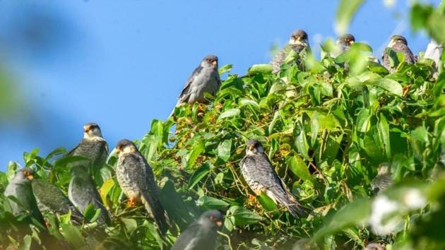
Nagaland today is one of India’s most culturally distinctive states — and one of its most ecologically important. In autumn, the village of Pangti becomes the world’s largest roosting ground for Amur falcons, when hundreds of thousands of birds fan across the Naga hills en route from Siberia to southern Africa. Conservation efforts have turned what was once a hunting ground into an extraordinary example of community-led protection.
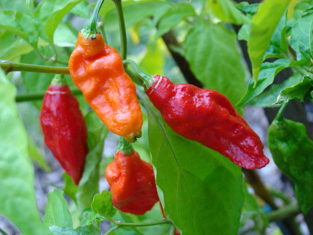
The state is equally famous for its Bhut Jolokia (also known as Naga Jolokia or ‘ghost chilli’), once certified among the hottest chillies in the world. It appears in kitchen gardens, market stalls, folklore, and even community competitions.
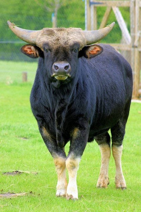
Another emblem is the mithun — a majestic semi-domesticated bovine found in the highland forests of Nagaland and neighbouring states. Mithun ownership traditionally signifies status, wealth and ritual prestige; they appear in rites of passage, bridewealth exchanges and clan histories, and remain central to Naga identity.

Botanically, Nagaland is a rhododendron hotspot, with dozens of species carpeting the higher ridges in spring. Forests shift quickly from subtropical to temperate, giving the hillsides bursts of colour that rival the Eastern Himalayas.
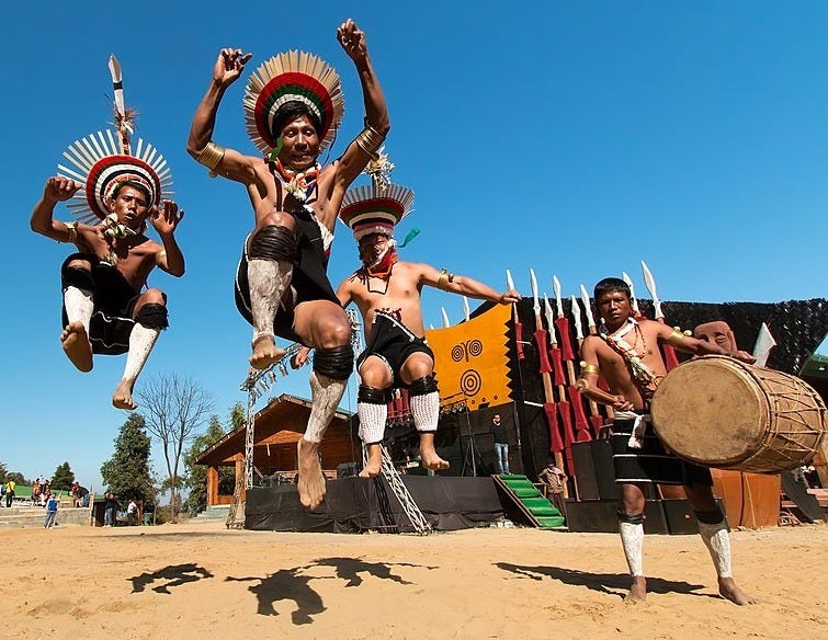
And every December, all these strands — tribal cultures, music, textiles, food, flowers and dance — are brought together at the spectacular Hornbill Festival. Marketed as the “Festival of Festivals”, it has grown into a cultural showcase of Naga tradition, attracting visitors from across India and abroad.
Nagaland’s modern history remains shaped by its complex political journey. After opposing inclusion in the Indian Union in 1947, the region experienced decades of insurgency before finally gaining statehood in 1963. Peace negotiations continue, but recent decades have brought greater stability, expanding education, rising literacy, and a renewed emphasis on cultural revival and environmental protection.
Nagaland is, in short, a state where tribes, languages, hills, forests, flowers, birds, chillies and cattle all matter very much.
KOHIMA — Capital
(Hin): कोहिमा kohima ‘Kewhi Village’
Angami: Kewhira / Kewhi-ra. Prob. from Ang: kewhi, a local wild flower; alt. kewhimia, ‘people living in the hills’.
Kohima was founded in 1878 as the headquarters of the Naga Hills district and became the state capital in 1963.
The name Kohima is a British corruption of local forms such as Kewhira or Kewhi-ra. Proposed derivations include:
Named for the Kewhi flower (identity uncertain).
Angami Kew-Hi-Ra, ‘a place welcoming all travellers’.
Angami kewhimia, ‘people living in the hills’.
A founder figure named Whinuo / Kewhira.
None of these has majority support — which is so Nagaland.
Kohima is chracterised by its churches, markets and the rhododendron-draped ridges. Surrounding Angami villages such as Kigwema and Jakhama keep older terrace patterns and clan traditions alive, giving the capital its cultural depth.
The Battle of Kohima (1944)
A pivotal moment in World War II — often called “the Stalingrad of the East”.
The Japanese Fifteenth Army attempted to cut through Imphal and Kohima to invade India. Kohima Ridge, only a mile long, became the site of a ferocious siege from April to June 1944.
The battle turned on the defence of the Tennis Court, where British and Indian troops held out at point-blank range.
Combined victories at Kohima and Imphal halted the Japanese advance and reversed the Burma campaign.
The Kohima War Cemetery marks the site, bearing the stark epitaph:
“When you go home, tell them of us and say,
For your tomorrow, we gave our today.”
Where Do Nagaland’s Place Names Come From?
Nagaland’s place names are a tapestry of Tibeto-Burman roots, colonial spellings, and shifting tribal histories. Most names come from the state’s major tribes — Angami, Ao, Sumi, Lotha, Konyak, Chakhesang — and describe the landscape with striking precision: a ridge, a river-bend, a bamboo grove, a clearing where warriors once met.
Because Naga villages often moved over time — after raids, feuds, or soil exhaustion — names frequently preserve the memory of older sites. British officers later standardised spellings, sometimes flattening tones and meanings, while Hindi forms on official signs added another layer.
The result is a vivid linguistic map with each name carrying a story of land, lineage and language.
TOP PLACES IN NAGALAND
Dimapur — ‘Big River Town’
Dimasa: prob. di, ‘river’; and mapur, ‘great settlement’, ‘city’.
The 350km Dhansiri river flows through here and heads towards the Brahmaputra a further 100km north.
An alternative suggestion recalls the tale of the the demoness Hidimbi in the Mahabhrata who lured Bhima so that her brother Hidimba could kill and eat him. Instead she fell in love with Bhima and protected him from her brother’s assault. She married the Pandava prince and gave birth to Ghatotkacha, the first ancestor of all Kacharis.
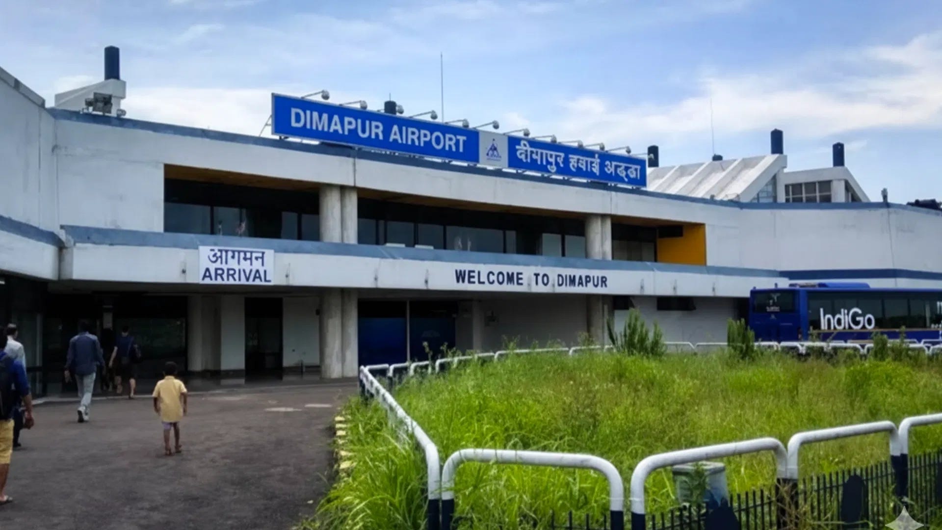
Once a capital of the Dimasa Kachari kingdom, it still preserves sculpted monoliths and palace remains around Rajbari. Modern Dimapur is Nagaland’s commercial and transport hub.
Dimapur is the largest city in Nagaland and has its only functional airport.
Kiphire — ‘Strong High Place’
From local Tibeto-Burman forms combining ideas of ‘strength’ or ‘firmness’ with ‘high place’ or ‘summit’.
Kiphire stands at the gateway to the Saramati range, where Nagaland rises to its highest peak.
Kiphire stands at the gateway to the Saramati range, where Nagaland rises to its highest peak. in a remote and dramatic landscape of ridges, deep valleys, riversn caves, hot springs and forests.
Zeme, Yimkhiung and Sangtam communities overlap here, each contributing to a multi-cultural feel.
Mokokchung — ‘Village on the High Ridge’
Ao: often linked to mokok, ‘hilltop’; and chung, ‘village’.
A later folk interpretation links the word mokok to the reluctant migration from Soyim, giving rise to the alternative gloss “forced settlers”, but the topographical derivation is the older and linguistically solid one.
Modern Mokokchung is a typical upland settlement: bamboo groves, terraced fields and long views toward the plains.
The surrounding Ao villages — Ungma, Longkum, Aongza — hold some of the most complete traditions of clan organisation, weaving and song.
Mon — ‘The High Country’
Konyak: prob. from a root meaning ‘high place’ or ‘elevated land’.
Perched near the Myanmar frontier, Mon is set in a landscape of steep ridges.
This is the heartland of the Konyak Nagas, known for woodcarving, log drums, tattoos and warrior feasts. Despite modern changes, Mon retains a rich material culture and remains one of Nagaland’s most atmospheric highland regions.
Peren — ‘Ridge Village’
Zeme/Liangmai: prob. from roots meaning ‘ridge’ or ‘crest’ combined with ‘village’.
Peren lies on the southern flank of Nagaland, where the hills roll into Manipur.
The name reflects the long ridges on which older settlements were sited, chosen for visibility and defence.
Bamboo and cane dominate the forests, and birdlife thrives in the subtropical valleys. Traditional architecture, with raised floors and sweeping roofs, still dominate in most villages.
Phek — ‘Village on the Hill’
Chakhesang: prob. from roots indicating ‘hill’ or ‘ridge settlement’.
Phek lies in cool, elevated country marked by sweeping terraces and pine-covered slopes.
The nearby Pfutsero plateau is known for low winter temperatures and spring rhododendrons that colour the ridges.
Chakhesang society emphasises community labour, clan unity and feasts of merit.
Tuensang — ‘The Cluster of Villages’
Chang/Sangtam roots: tuen, sometimes ‘many’ or ‘central’; tsang, ‘village’ or ‘settlement’.
Tuensang stretches across one of Nagaland’s largest districts, where Chang, Sangtam, Yimkhiung and Khiamniungan traditions meet. It is a landscape of forests and long belts of mixed cultivation. Villages sit on saddles overlooking narrow valleys, many linked by old trade paths toward Myanmar.
The name’s sense of ‘many settlements’ fits the district’s patchwork of languages, myths and weaving styles.
Wokha — ‘Head of the Mountain’
Lotha: wokha, ‘summit’, ‘hill-top’, ‘head of the hill’.
Wokha occupies a long ridge rising above orchards, fisheries, river basins, terraced fields, highland villages and forested slopes. Its Lotha name reflects the prominence of the ridge itself, long used as a vantage for settlement and cultivation.
Nearby Pangti hosts the extraordinary migration of Amur falcons, when hundreds of thousands of birds roost in the forests before crossing the Indian Ocean. give Wokha a landscape both cultivated and wild.
Zunheboto — ‘Hill of Deep Waters’
Sumi: from zünhebo, ‘deep water’ or ‘flowing water’; and –to, ‘hill’.
Zunheboto spreads across rounded uplands threaded with streams and freshwater springs.The district’s name captures the blend of water and hill that defines much of the Sumi homeland.
As the cultural centre of the Sumi Nagas, it is known for choral music, drum rhythms and the distinctive shawls worn during festivals.homeland.
NAGALAND PLACE-NAME GLOSSARY
–bang / –pang — ‘open place’, ‘clearing’, ‘junction’.
Pangti (Wokha): famous for the Amur falcon roosts; name reflects an open shelf of land above the valley.
–chan / –jan — ‘field’, ‘cultivated slope’, ‘terrace’ (Sema/Sumi).
Phuyemchan (Zunheboto region): a terrace landscape associated with Sumi jhum fields.
–ching / –chingbu — ‘hill’, ‘ridge’, ‘upland’ (Ao/Konyak).
Chingmei (Mon district): village on a ridge with sweeping views toward Myanmar.
–ga / –ka — ‘village’, ‘settlement’ (generic TB).
Chakabama (Kohima district): ‘Chakaba village’, on a long saddle linking Kohima to Pfutsero.
–gar / –garh — ‘fort’, ‘stockade’ (Sanskrit/Hindi; colonial).
Chakhesang-garh appears on colonial survey maps (though no local fortification existed); an artefact of British cartography.
–jü / –zü — ‘water’, ‘pool’, ‘wet hollow’ (Ao).
Longkhumzü (Ao region): named for a spring-fed pool near the old settlement.
–kong — ‘valley’, ‘river corridor’ (Ao).
Tzurangkong (Mokokchung): a cluster of Ao villages in the deep valley of the Tzürang River.
For more on Indian place names and history - see Place Names Wallah
For a journey through tribal India & Sri Lanka see - Headhunting with Marguerite